Click here to read the aims of the walk programme.
The walks will normally set off from the starting point at
10:30 on the fourth Tuesday of the month.
There will be two walks each day. Details of the longer one are given below.
A shortened version will be led by Zimmy.
If you need extra information please ring one of these numbers
01509 842 508 or 07752 650 486 (Gordon)
01509 214 829 (Zimmy)
or the Walk Leader (See below)
| Date | 26 Apr 2005 - "Emphasis on flowers" |
| Walk Info | A repeat of last year's April walk. The first flowers of the season will be appearing and some hillsides will have a good covering of flowers. Some spectacular scenery, especially in the Miller's Dale and Monsal Dale regions. |
| Distance | 12 km = 7.5 miles |
| Worst climb | 134 metres |
| Leader | Gordon Murray |
| Telephone | 01 509 842 508 |
| Mobile | 07 752 650 486 |
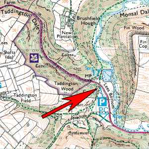
| Start | White Lodge Car Park at bottom of Taddington Dale [Pay and Display] |
| Start Grid Ref | SK 170 706 |
| Travel | Quickest possible time from Loughborough 63min Follow A6 from Bakewell towards Buxton. Car Park is on left about 4 miles beyond Bakewell. Allow 1hour 20 minutes for journey from Loughborough. |
| Map of start | |
| Extra map of start |
 |
| Extra Info | A hilly route |
| Toilets at start? | Yes |
| Date | 24 May 2005 - Lathkill Dale |
| Walk Info | Route will be a loop to the south, going as far as Bradford Dale. Distance 14km = 8.7miles |
| Worst climbs | 80m and 120m |
| Leader | Gordon Murray |
| Telephone | 01 509 842 508 |
| Mobile | 07 752 650 486 |
| Start | The car park in Over Haddon Village. This is the one beside the little road descending into Lathkill Dale. Nearby at SK 205 665 is a craft centre and coffee shop. [Now closed-down!] |
| Start Grid Ref | SK 203 664 |
| Travel | Quickest possible time from Loughborough 60min Two possibilities. The first is to travel to Bakewell and take the Monyash Road (B5055) from the centre. Follow it for one mile then fork left to Over Haddon 1m. The other route is along the A515 North from Ashbourne. Beyond the Hartington turn, take the B5055 to your right. Pass through Monyash on the B5055 and in 2m fork right to Over Haddon. |
| Map of start | |
| Extra map of start |
 |
| Extra Info | Parking fee Ł3 in 2005 |
| Toilets at start? | Yes |
| Date | 28 June 2005 - Bonsall/Winster loop |
| Walk Info | The walk is around a loop between Bonsall and Winster. The longer route includes a longish ascent north of Bonsall! Distance 15.9km = 9.9miles [Full walk] Distance 11.1km = 6.9miles [Shorter walk] |
| Worst climb | 185m on longer route 100m on shorter route. |
| Leader | John Shaw |
| Telephone | 01 509 234 495 |
| Mobile | 07 ### ### ### |
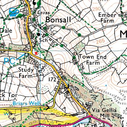
| Start | A gravelled car park just downhill from Bonsall. |
| Start Grid Ref | SK 279 579 |
| Travel | Quickest possible time from Loughborough 47min If approaching via the A6, turn left at the traffic lights before Matlock Bath and then turn right beyond Cromford village pond. After 0.8 miles turn right at Via Gellia Mill, signposted Bonsall, and use the car park on the right before entering the village. |
| Map of start | |
| Extra map of start |
 |
| Extra Info | |
| Toilets at start? | Yes. Across road to NW. Small building slightly uphill. |
| Date | 23 August 2005 - Heights of Abraham |
| Walk Info | The walk is a fairly hilly one. We walk up and along the ridge past the Heights of Abraham before crossing over the hill into Bonsall. From there we descend to the wooded Via Gellia valley and then cross the Cromford road to climb almost to Black Rocks. Finally we descend to the canal, along which we walk to the finish. |
| Worst climb | 170 metres and one of 112 metres |
| Leader | Tony Collins |
| Telephone | 01 509 214 691 |
| Mobile | 07 930 966 724 |
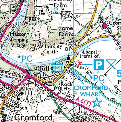
| Start | Car park at Cromford Wharf (which is not in Cromford village!) |
| Start Grid Ref | SK 300 571 |
| Travel | Quickest possible time from Loughborough 46min Assuming that you are heading north along the A6, turn right at the traffic lights as you approach Matlock Bath. There is a short narrow section past the visitors centre and then the car park is in a large field on your right. |
| Map of start | |
| Extra map of start |
 |
| Extra Info | |
| Toilets at start? | Yes |
| Date | 26 July 2005 - Dovedale |
| Walk Info | The walk goes up one side of Dovedale and down the other. It follows some little-used paths on the cliffs for part of the way and some meadow paths on the farmlands either side of the dale. |
| Worst climb | 142 metres |
| Leader | John Graham |
| Telephone | 01 509 239 293 |
| Mobile | 07 949 892 770 |
| Start | The car park south of Thorpe Cloud. Parking fee. |
| Start Grid Ref | SK 146 509 |
| Travel | Quickest possible time from Loughborough 49min Head north out of Ashbourne and turn left after 1 mile to Thorpe. Pass through Thorpe and in about 0.7 miles along the Ilam road turn right to the car park. |
| Map of start | |
| Extra map of start |
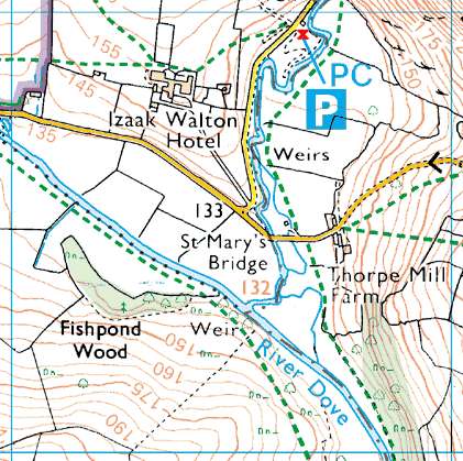 |
| Extra Info | Often a tea stall in the car park. A short stroll away, the Izaak Walton Hotel serves excellent teas. |
| Toilets at start? | Yes |
| Date | 23 August 2005 - Heights of Abraham |
| Walk Info | The walk is a fairly hilly one. We walk up and along the ridge past the Heights of Abraham before crossing over the hill into Bonsall. From there we descend to the wooded Via Gellia valley and then cross the Cromford road to climb almost to Black Rocks. Finally we descend to the canal, along which we walk to the finish. |
| Worst climb | 170 metres and one of 112 metres |
| Leader | Tony Collins |
| Telephone | 01 509 214 691 |
| Mobile | 07 930 966 724 |
| Start | Car park at Cromford Wharf (which is not in Cromford village!) |
| Start Grid Ref | SK 300 571 |
| Travel | Assuming that you are heading north along the A6, turn right at the traffic lights as you approach Matlock Bath. There is a short narrow section past the visitors centre and then the car park is in a large field on your right. |
| Map of start | |
| Extra map of start |
|
| Extra Info | |
| Toilets at start? | Yes |
| Date | 27 September 2005 - Hartington |
| Walk Info | Figure of eight from Village. Via limestone ridge northwards above the River Dove to Pilsbury Castle. Continue NW to Crowdecote and then southwards, through the edges of Staffordshire, parallel to the River Manifold. Finally turn east through Sheen and back to Hartington. (13.7km = 8˝ miles) |
| Worst climb | Two of 65 metres |
| Leader | John Harries |
| Telephone | 01 509 234 275 |
| Mobile | 07 732 193 119 |
| Start | Meet at Hartington Village. Park anywhere in village. Walk starts at village pond. There is a car park to the SW of the village, but it is expensive. |
| Start Grid Ref | SK 128 625 |
| Travel | Quickest possible time from Loughborough 60min |
| Map of start | |
| Extra map of start |
 |
| Extra Info | A rather special cheese shop near the start/finish |
| Toilets at start? | Yes. A short stroll along the road leading SW from village centre. |
| Date | 25 October 2005 - "Autumn Leaves" |
| Walk Info | Similar to the 2004 walk but using different paths. Hope for a sunny day and bring your camera. |
| Worst climb | 116 metres |
| Leader | ########## |
| Telephone | 01 509 ### ### |
| Mobile | 07 ### ### ### |
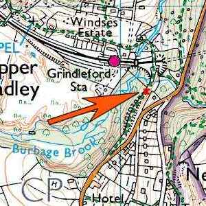
| Start | Meet at Grindleford Railway Station car park. Park along the road leading to it. |
| Start Grid Ref | SK 251 788 |
| Travel | M1 - A617 to Chesterfield - A619 to Baslow A623 to the traffic lights at Calver crossroads. Turn right, to Grindleford, then straight on to Nether Padley. About half a mile beyond the river bridge, the railway station is down a small road to your left.
|
| Map of start | |
| Extra map of start |
 |
| Extra Info | |
| Toilets at start? | Yes, but at cafe for customers! |
