Last updated 28.6.2017
| Date | 10:30 on Tuesday 23 May 2017 - Bonsall/Winster |
| Walk Info (long walk) |
[009] A roughly square route with Bonsall and Winster as corners. Includes a northwards bulge near Wensley. |
| Distance | 15.9 km |
| Ascents | 470 m |
|
Leader (long walk) |
|
| Walk Info (short walk) |
[009z] Bonsall to Winster and back by two different paths |
| Distance | 11.2 km |
| Ascents | 240 m |
|
Leader (short walk) |
|
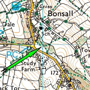
| Start | If available, the car/lorry park below Bonsall, adjacent to the football pitch. Otherwise on the roads nearby. {We have used the park many times, but we have never been sure of our access rights} |
| Grid Ref | SK 279 579 |
| Travel | A6 to Cromford and turn L on to the A5012 at traffic lights. Turn R 200yds after the traffic lights. 1 mile later take R turn uphill to Bonsall.
Google Maps time from Loughborough 57min for 46miles |
Try clicking on the signpost to get a map. Then zoom out for a suitable route-plan map There will be a link at the base of the map giving a "nearest postcode" for your Satnav. |
 |
| Aerial map of start |
For Google satellite map of the start point, click here. |
| Extra Info | Lunch stop in Winster. |
| Toilets at start? | Yes. Fairly basic! |